



GPS Tracker

وصف لـGPS Tracker
With GPS Tracker application you can transform your Android device to GPS device.
HOW TO USE: http://www.gps-server.net/android
This application may be useful for:
- Tracking your phone online in real time;
- Record and review tracks;
- Recover lost phones;
- Personal safety;
- Save money for business owners.
GPS Tracker features:
- Application gets location using GPS and AGPS;
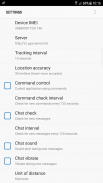
- Possibility to change tracking interval;
- Possibility to change location accuracy settings;
- Battery level percentage is sent together with every location;
- If Internet is lost, application will save locations and upload them later;
- Possibility to control application via web browser using commands;
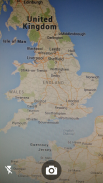
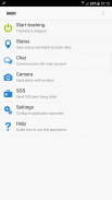
- Camera allows to make photos and upload to user account with last location;
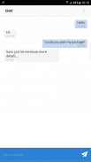
- Communication with main account via Chat;
- SOS long click button;
- Automatic startup on phone restart;
- Password protection;
- Application runs in background.
GPS-server.net features:
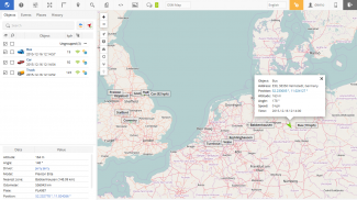
- In real-time tracking mode you will see your current location on the map, or the last position when your GPS device connection was active.
- Server can generate and send you notifications via e-mail or notify with a pop-up window, when something happens. That kind of events might be when object enters or exits geofence area, violates speed limit, presses SOS button, GPS device loses connection and even starts engine or opens door.
- With geofences you are able to make a virtual perimeter on geographic areas that have specific interest for you. The main reason to have Geofences is to control whether the units stays within it or not, so that when the geofencing unit enters or exits the area a notification is generated.
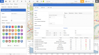
- POI (Points of Interest) allow you to put markers at the locations that might be interesting or useful. You can also name the place, add short description, attach an image or even video to it.
- The history of your tracks can be put on the map with addition information, such as time/speed graph, stops, reports, etc. There is also possibility to generate group reports for your objects.
- You can search for addresses from the search panel, enter point coordinates. Also you can use tools for calculating distances between places on the map and etc.
- Possibility to manage GPS devices on your own, add extra sensors. Customizable user settings.
- Mobile version of tracking application, which is designed to run on mobile devices.
باستخدام تطبيق GPS Tracker ، يمكنك تحويل جهاز Android إلى جهاز GPS.
كيفية الاستخدام: http://www.gps-server.net/android
قد يكون هذا التطبيق مفيدًا لـ:
- تتبع هاتفك عبر الإنترنت في الوقت الحقيقي.
- سجل ومراجعة المسارات.
- استعادة الهواتف المفقودة.
- السلامة الشخصية؛
- توفير المال لأصحاب الأعمال.
ميزات GPS Tracker:
- يحصل تطبيق الموقع باستخدام GPS و AGPS.
- إمكانية تغيير الفاصل الزمني تتبع.
- إمكانية تغيير إعدادات دقة الموقع.
- يتم إرسال نسبة مستوى البطارية جنبا إلى جنب مع كل مكان.
- في حالة فقد الإنترنت ، سيقوم التطبيق بحفظ المواقع وتحميلها لاحقًا ؛
- إمكانية التحكم في التطبيق عبر متصفح الويب باستخدام الأوامر ؛
- الكاميرا تسمح لجعل الصور وتحميلها إلى حساب المستخدم مع الموقع الأخير.
- التواصل مع الحساب الرئيسي عبر الدردشة.
- SOS انقر فوق زر طويل.
- بدء التشغيل التلقائي عند إعادة تشغيل الهاتف.
- حماية كلمة المرور؛
- يعمل التطبيق في الخلفية.
ميزات GPS-server.net:
- في وضع التتبع في الوقت الفعلي ، سترى موقعك الحالي على الخريطة ، أو آخر موضع عندما كان اتصال جهاز GPS نشطًا.
- يمكن للخادم إنشاء وإرسال إعلامات إليك عبر البريد الإلكتروني أو الإخطار من خلال نافذة منبثقة ، عندما يحدث شيء ما. قد يكون هذا النوع من الأحداث عندما يدخل الكائن أو يخرج من المنطقة الجغرافية ، وينتهك الحد الأقصى للسرعة ، ويضغط على زر SOS ، ويفقد جهاز GPS الاتصال ويفتح المحرك أو يفتح الباب.
- مع geofences ، يمكنك إنشاء محيط افتراضي على المناطق الجغرافية التي لها اهتمام خاص بك. السبب الرئيسي لوجود Geofences هو التحكم في بقاء الوحدات داخلها أم لا ، بحيث عندما تدخل وحدة geofencing إلى المنطقة أو تخرج منها ، يتم إنشاء إشعار.
- تتيح لك النقاط المهمة (POI) وضع علامات في المواقع التي قد تكون ممتعة أو مفيدة. يمكنك أيضًا تسمية المكان أو إضافة وصف قصير أو إرفاق صورة أو حتى فيديو.
- يمكن وضع محفوظات المسارات الخاصة بك على الخريطة مع معلومات الإضافة ، مثل الرسم البياني للوقت / السرعة ، والإيقاف ، والتقارير ، وما إلى ذلك. هناك أيضًا إمكانية لإنشاء تقارير جماعية للكائنات الخاصة بك.
- يمكنك البحث عن عناوين من لوحة البحث ، أدخل إحداثيات النقطة. كما يمكنك استخدام أدوات لحساب المسافات بين الأماكن على الخريطة وغيرها.
- إمكانية لإدارة أجهزة GPS بنفسك ، إضافة أجهزة استشعار إضافية. إعدادات المستخدم للتخصيص.
- نسخة للجوال من تطبيق التتبع ، والتي صممت لتعمل على الأجهزة المحمولة


